 geo.be Metadata Catalog
Greater North Sea, incl. the Kattegat and the English Channel
Type of resources
Topics
INSPIRE themes
Keywords
Contact for the resource
Provided by
Years
Formats
Representation types
-

This dataset is part of the 2018 Belgian submission for the Marine Strategy Framework Directive (MSFD) linked to descriptor 5, criterion 2. This dataset contains the average of the 90th percentile chlorophyll a concentration during the growing season (march-october) in the Belgian part of the North Sea for the years 2011-2016. Chlorophyll a concentration (Chl) was generated from satellite daily data from ocean colour sensors. Data is supplied at approximately 1 km resolution on a geographical grid with equal spacing in longitude and latitude covering the described region.
-

The Royal Decree of 22 May 2019 establishing a marine spatial plan defines 1 coastal protection experiments zone: Zone for coastal protection experiments (Art. 16§2). It replaces the 2014 Marine Spatial Plan, which is included for completeness. The Royal Decree of 20 March 2014 establishing a marine spatial plan defines in its Art. 12. §1 one zone for coastal protection experiments. This zone is made available digitally in the resource described by this metadata document. Please refer to the Belgian official gazette (\"Moniteur belge/Belgisch Staatsblad\") for official reference information.
-

The Royal Decree of 22 May 2019 establishing a marine spatial plan defines 11 military use and storage sites for war munition zones: Exercise area for sweeping mines (Buiten Ratel) (Art. 17§1), Exercise area for sweeping mines - NB-01 (Westhinder) (Art. 17§1), Exercise area for sweeping mines - NBH-10 (Wenduine) (Art. 17§1), Exercise area for sweeping mines - QZR 040 (Art. 17§1), Munition destruction area (Art. 17§2), Area for shooting exercises on floating objects (Art. 17§3), Area for exercises in shallow waters (Art. 17§4), Area for shooting exercises from land - big sector (Art. 17§5), Area for shooting exercises from land - medium sector (Art. 17§5), Area for shooting exercises from land - small sector (Art. 17§5), Storage site for war munition Paardenmarkt (Art. 18§1). It replaces the 2014 Marine Spatial Plan, which is included for completeness. The Royal Decree of 20 March 2014 establishing a marine spatial plan defines in its Art. 13. and Art. 14., resp. nine zones for military use and one storage site for war munition: three zones for shooting exercises from land direction sea (Art 13. § 1 small sector, Art 13. § 1 medium sector, Art 13. § 1 large sector), four exercise areas for sweeping mines (Art 13. § 3, Exercise area 1 for sweeping mines, Art 13. § 5, Exercise area 2 for sweeping mines, Art 13. § 9, Exercise area 3 for sweeping mines, Art 13. § 13, Exercise area 4 for sweeping mines), one area for shooting exercises on floating objects (Art 13. § 7), one area for defusing mines (Art 13. § 11) and one zone to safeguard the closed storage site for war munition \"Paardenmarkt\" (Art. 14. § 1). These zones are made available digitally in the resource described by this metadata document. Please refer to the Belgian official gazette (\"Moniteur belge/Belgisch Staatsblad\") for official reference information.
-
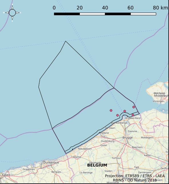
This dataset is part of the 2018 Belgian submission for the Marine Strategy Framework Directive (MSFD) linked to descriptor 8, criterion 3. This dataset gives an overview of the observed slicks during aerial survey operations of the Belgian part of the North Sea (2011-2016). Related to significant acute pollution, it includes the observations linked to the Flinterstar incident in 2015. Besides this, all observations of illegal discharges of MARPOL (International Convention for the Prevention of Pollution from Ships) annex I and II substances are included as an additional dataset.
-
This dataset is part of the 2018 Belgian submission for the Marine Strategy Framework Directive (MSFD) linked to descriptor 11, criterion 1. This dataset describes the impulsive noise generated during percussion pile emplacement for offshore wind farm construction and unexploded ordnance (UxO) explosions. Impulsive underwater sound (pressure) was measured during pile driving operations in Belgian waters, for different types of foundations (monopiles of different diameters, foundations of ducts with a smaller diameter) and hydraulic hammers with different energy powers. The results of measurements at Bligh Bank and Thornton Bank, with a resulting extrapolation of zero to peak noise level (Lz-p) at 750m and Sound Exposure Level (SEL) (no mitigation measures deployed), are presented (Norro et al., 2013).
-

The Royal Decree of 22 May 2019 establishing a marine spatial plan defines 6 energy, cable and pipeline zones: Area 1 for renewable energy (Eastern zone) (Art. 8§1), Area 2 for renewable energy (Noordhinder North) (Art. 8§2), Area 3 for renewable energy (Noordhinder Zuid) (Art. 8§3), Area for renewable energy - zone 4 (Fairybank) (Art. 8§3), Modular offshore grid for transmission of energy (Art. 8§5), Pipelines and cables corridor (Art. 9§1). It replaces the 2014 Marine Spatial Plan, which is included for completeness. The Royal Decree of 20 March 2014 establishing a marine spatial plan defines in its Art. 9. five dredged material disposal sites (Dredged material disposal site S1, Art. 9 § 6.1°; Dredged material disposal site S2, Art. 9 § 6.2°; Dredged material disposal site Bruggen en Wegen Oostende, Art. 9 § 6.3°; Dredged material disposal site Bruggen en Wegen Zeebrugge Oost, Art. 9 § 6.4°; Dredged material disposal site Bruggen en Wegen Nieuwpoort, Art. 9 § 6.5°). These zones are made available digitally in the resource described by this metadata document. Please refer to the Belgian official gazette (\"Moniteur belge/Belgisch Staatsblad\") for official reference information.
-
This dataset is part of the 2018 Belgian submission for the Marine Strategy Framework Directive (MSFD) linked to descriptor 8, criterion 1. This dataset is part of the 2018 Belgian submission for the Marine Strategy Framework Directive (MSFD) linked to descriptor 8, criterion 1. This dataset contains the concentrations of priority substances (tributyltin, polycyclic aromatic hydrocarbons (PAHs) and polybrominated diphenylethers (PBDEs)) measured in the water column at three stations in the Belgian part of the North Sea between 2009 and 2014 (as reported in the frame of the WFD in 2016). In total, 45 different parameters are measured.
-

The Royal Decree of 22 May 2019 establishing a marine spatial plan defines 5 nature conservation areas: Special area for conservation 'The Flemish Banks' (Art. 7§1), Special area for conservation 'Vlakte van de Raan' (Art. 7§3), Special protection area for birds - SPA 1 (Art. 7§5.1°), Special protection area for birds - SPA 2 (Art. 7§5.2°), Special protection area for birds - SPA 3 (Art. 7§5.3°). It replaces the 2014 Marine Spatial Plan, which is included for completeness. The Royal Decree of 20 March 2014 establishing a marine spatial plan defines in its Art. 7., six nature conservation sites: two special areas for conservation (Art. 7. §1, Special area for conservation 'Vlaamse Banken' and Art. 7. §3, Special area for conservation 'Trapegeer stroombank'), three special protection zones for birds (Art7§4.1°, SBZ1, Art7§4.2°, SBZ2, Art7§4.3°, SBZ3), and one marine reserve (Art7§8, Marine reserve 'Baai van Heist'). These zones are made available digitally in the resource described by this metadata document. Please refer to the Belgian official gazette (\"Moniteur belge/Belgisch Staatsblad\") for official reference information.
-
The Royal Decree of 22 May 2019 establishing a marine spatial plan defines 6 measuring poles: Measuring pole MOW.0 (Art. 21§2), Measuring pole MOW.1 (Art. 21§2), Measuring pole MOW.2 (Art. 21§2), Measuring pole MOW.3 (Art. 21§2), Measuring pole MOW.4 (Art. 21§2), Measuring pole Westhinder (Art. 21§2). It replaces the 2014 Marine Spatial Plan, which is included for completeness. The Royal Decree of 20 March 2014 establishing a marine spatial plan defines in its Art. 15. §3, one set of measuring pole locations. These locations are made available digitally in the resource described by this metadata document. Please refer to the Belgian official gazette (\"Moniteur belge/Belgisch Staatsblad\") for official reference information.
-

The dataset contains the borders of the Belgian marine waters in the North Sea and the different geographical areas (‘reporting units’) used when reporting in the frame of the the Marine Strategy Framework Directive 2008/56/EC (MSFD) and the Water Framework directive 2000/60/EC (WFD). The ecological status in the frame of WFD is reported for the coastal waters, defined as the one-nautical mile area, while the chemical status needs to be reported for the territorial waters (up to 12 nautical miles). MSFD requires information for the whole area, encompassing the territorial waters and the Belgian Exclusive Economic Zone. For some descriptors, results have been reported separately for the WFD subdivisions during the update of the initial assessment in 2018.